Population: The Total Urban Population of Xuzhou City counts around - no information available.
The China Report
The Xuzhou Report is part of the overall website www.ChinaReport.com & www.drben.net
Learn about what is new on this Site from below window.
ChinaReport.comat
A Full listing of Xuzhou Landmarks, Monuments, Hotspots and other sites of importance in alphabetical order. Search through the list to find your Full Report and Photo-Virtual Tour of each monument or landmark within the City, or Region of Xuzhou City in Zhejiang Province of China (PRC).
Public Transport in Huzhou
The Main and only Railway Station of Huzhou, located due East of the City Center of Huzhou and some distance away along the highway to the East. As the arrival point for many, the Main Station is home to a number of essential Services. Huzhou also has its own International Airport !
Huzhou has a Railroad Station.
There is no information available on the History of Xuzhou at this Time.
No Information Available.
The Three main Ethnic Groups represented in Xuzhou City are the...
No information available at this Time.
Find DrBen and ChinaReport on Facebook with the latest from www.drben.net.
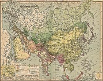
China Report - Colonialism - Growth of Colonies & Japan after 1801 AD
A Map drawing of the Eurasian continent , parts of North-East Africa and the Middle East in the 19Th Century between 1801 AD and 1900 AD. Focal points are the expansion of western colonial posessions of Portugal, Britain and France, as well as Russia moving from West to East. Labeled seperately is the later Rise of the Empire of Japan in the East.
Included in this Map are the main cities across the continent with their brief histories and events during the 19Th Century. Marked in Colors for clarity are the various colonial and imperialist Nations. As relating to China; special attention is payed to so called Treaty Ports. The First Treaty Ports were forced open by Britain in the year 1841 AD, but counted over 80 in total by the end of the 19Th Century. The most important Treaty Ports in China are marked and described with a short history where the map allows.